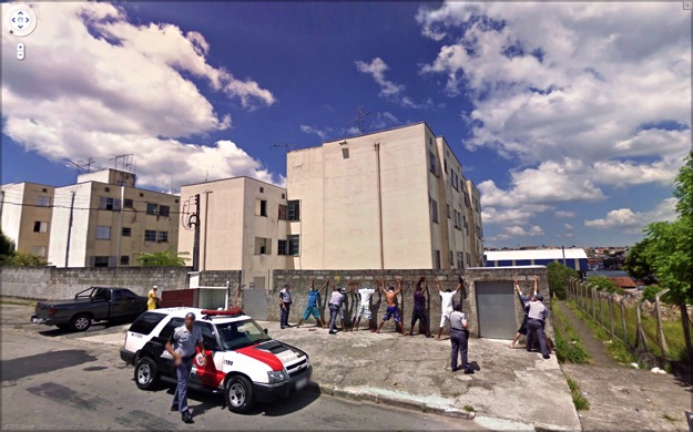
Google Streetview Capture · Pervasive mapping assimilates events as objects of cartography.
Jon Rafman (2010)
[ source ]
In that Empire, the Art of Cartography attained such Perfection that the map of a single Province occupied the entirety of a City, and the map of the Empire, the entirety of a Province. In time, those Unconscionable Maps no longer satisfied, and the Cartographers Guilds struck a Map of the Empire whose size was that of the Empire, and which coincided point for point with it. The following Generations, who were not so fond of the Study of Cartography as their Forebears had been, saw that that vast Map was Useless…
In the Deserts of the West, still today, there are Tattered Ruins of the Map, inhabited by Animals and Beggars; and in all the Land there is no other Relic of the Disciplines of Geography.
- Jorge Luis Borges, On Exactitude in Science
Pervasive cartography: A continuous, distributed real-time mapping. Panopticon and Aleph — control and dizzying perspective — collide to induce a spatio-temporal vertigo played out in a digital landscape presented to us as ‘real’, served up precisely at its vanishing point. Curated images from Google StreetView vans around the world give us a glimpse into this future practice; 9-eyed drones systematically scouring all terrestrial space. Mapping now deals with microscopic, heavily localised events whose geographic and temporal relationships become the object of analysis.
Photosynth · Synthesising 3D cartographies from crowdsourced photographic data.
Microsoft Research Labs (2009)
[ source ]
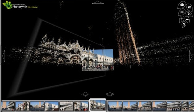
Decentralised platforms such as Photosynth present the future of pervasive mapping, arising as an inevitable consequence of mass geographic data generation. What’s notable is not the mass amateurisation, but our consensual hallucination turning on the physical landscape, the latter having no option but to allow its absorption into an emergent transactive memory.
Omni-location of everything in real-time presents us with a dispensable real whose image soon supercedes it in the form of data, forecasts, AR turned simulacral. Services like Skyhook promise to “predict the density of people in predefined urban square-block areas worldwide at any hour, any day of the week” through the sensing of mobile telecommunications traffic, whilst the assignment of an IP address for every component of the built environment, from buildings to traffic lights, promises both a newly interactive environment and a heavily shackled one.
Whilst the parametrisation of space can be seen as part of a culture of networked interactivity that heralds “the end of spectacle” (Baudrillard), the mapping itself could be considered intrinsic to the mechanisms of control that themselves pervade the process.
Best of the web
- Best Non Gamstop Casinos
- Non Aams Casino 2025
- Betting Sites UK
- Non Gamstop Casinos
- Casinos Not On Gamstop
- Casino Sites Not On Gamstop
- UK Casinos Not On Gamstop
- Migliori Bookmakers Non Aams
- Slots Not On Gamstop
- Casino En Ligne
- Meilleur Casino En Ligne
- Non Gamstop Casino Sites UK
- Casinos Not On Gamstop
- UK Casino Not On Gamstop
- Migliori Casino Non Aams
- Casino Sites UK
- Non Gamstop Casinos
- UK Casino Not On Gamstop
- Casinos Not On Gamstop
- Online Slot Sites UK
- Casino Sites Not On Gamstop
- Non Gamstop Casinos UK
- UK Casino Sites Not On Gamstop
- Slots Not On Gamstop
- Slot Online Migliori
- Non Gamstop Casino
- Casino Crypto En Ligne
- Casino En Ligne Crypto
- Paris Sportifs Belgique
- Meilleur Casino Belgique
- Casino Non Aams Sicuri
- 씨벳 먹튀
- Malaysia Online Casino
- Casino En Ligne Bonus Sans Dépôt
- Migliori Casino Senza Documenti
- Casino Italiani Non Aams
- Siti Di Scommesse Non Aams
- Casino En Ligne France
- Casino En Ligne Qui Paye Le Plus
- Migliori Casino Non AAMS
- Meilleur Casino En Ligne
- Migliori App Poker Per Android
- Casino En Ligne France